


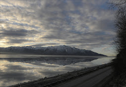
 The Hanging Valley is the second one over, but first I have to cross the grass and stone-cluttered slopes to reach it. So, off again and away from the human trail, into new places to unclutter my mind. First through one valley, over a pile of scree, and along the flowered hill; my goal is to enter the second Hanging Valley, and then climb up to the head of it, where a small glacier sits. Now mostly melted, this glacier, no more than a quarter mile square, is a is melting remnant of the last Ice Age . In its wake, down the the lengthe of the valley, are a piles of rock debris. And over this debris field, I will make my way up to Paradise Pass. Here, at a mile above sea level, the view should be wide in scope. To the west of the Pass is an intersection of two valleys, and another shrinking glacier on the inside corner of them. Once this glacier blocked the way to the other side. On the Map, in the furthest valley, lies Grizzly Bear Lake, the source of North Fork Ship Creek. So, I keep these thoughts in mind, as Pancho, my dog follows me over scree and steep slope. I will be about 800 feet above the trail as I cross over to the lip of Paradise Valley.
 Fog. Then a few drops of rain and grayness. The slope becomes slippery as I move through the fields of dying flowers. Then over a talus area, loose and angled; it slows down my pace--take a step, slide and regain balance. Below, the waters of Raven creek and a side creek join at a ford along the main trail. A few tents, in colorful display, are scattered across the this side of the valley. They seem so tiny and insignificant among Glaciers and the tilted hills, not part of the geological plan. I look around at the pyramids of mountains, the abraded shelves without plant cover, and the pathway through the vally, where once miles of ice had filled. And once I reach the entrance of Paradise Valley, I am greeted with other reminders of change: monoliths of stone and deep cuts in the lip where water gushes downwards. Staring up is a rubble field and dark walls of loose, mixed sedimentary rock--something older than the glaciers.
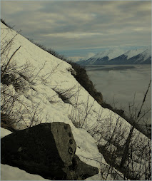
The weight of the pack now slows me down. I feel the straps cutting into my shoulders. And more steep slope and fields of broken, sharp, and angled rock. From the lower part of the valley the glacier remains hidden in a bowl higher up, somewhere near the dark line of the silhouetted Pass, below the notch. I travel as much as I can along the sheep trails that thread their away amongst this damaged ground. Huge ditches have ground their way at angles across the valley, making my travel more circuitous. I spot a rounded hill, now a place of lichens and alpine plants, to guide my way upwards. Still, the barriers of rock become more visible above as I ascend to the last wall of loose material. I step and slide up these mounds, as though nothing solid to get a firm foothold on. Even the sides of the valley is littered with the crumbing tops; the orange and blue streaks of land once beneath the water.
The rock gives way with each step. I angle over and finally step over its rim. The glacier is small, not like the ones in the main valley, smaller than even on the map. Around its bowl the the rock walls are steep. However, a small bench of talus forms around the opposite side of the glacier, angling up to where a slide of loose, smaller rock conneccts by a narrow strip below the Pass. Here is the way to the top. But the hike up will be difficult, not for technical reasons, but because of the weight I am carrying and the looseness of the scree above. The heavy materials have gravitated to the bottom, leaving the smaller pieces in the draw below the Pass. Everything here shifts and tumbles more with each gain of height, 600 feet up. So, I look for larger footholds--plants or bedrock or larger stones--to complete the final steps to the Pass. Barely 7-8 feet wide, The Pass at one mile above sea level provides the view I knew it would. But only for a moment would I see the silver shape of Grizzly Lake. The slope on the other side was steeper, curving downwards at the bottom. Two miles away was the Lake. Between lay aa waste land of dark rock debris, hidden ice below the surface, and a huge mounds of earth opposite the glacier along the curve of the two valleys. To get down meant leaving the heavy pack and looking for a pathway between the drop at the base of the hill. Two miles to the Lake. Another two hours or more to get back. I slid off the pack and opened it up. I took out the coat and unzipped the pocket. Here I put some food and a bottle of juice. If I was to go, I wanted to go light. Down in a snow patch at the base were broken signs of bear tracks. I would need the gun too. But what worried me most was the fog gathering, moving in waves against the hills, and thickening. I wouldn't be able to see the ground ahead near the glacier. The slope offered another problem with the angle near the bottom. However, I had to know the condition of the slope. I slung on the gun and headed downwards. It was nasty and loose. Even the large rocks moved and the steepness offered little hold firmness of step. I angled over to the right, searching for a way around the drop. I found it near one of the edges, but it was loose here near an edge, not something to retrace in the gathering fog. Another day would have to do and I headed back up to the Pass.

Amazing pictures!
ReplyDelete